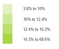
The map appearing on the home page of our website measures the percentage of individuals with incomes below the After-Tax Low Income Measure (LIM-AT) threshold at the census division level for 2015.
The map includes four categories:

The map was created using the following data product available from the Community Data Program catalogue: F-18: After-tax low income status (based on census family low income measures, LIMs) by family type and family composition, 2015. In addition to census divisions, these variables are also available for Census Agglomerations, Census Metropolitan Areas, Census Subdivisions, Census Tracts, Forward Sortation Areas, Postal Cities, Provinces and Territories, and Rural Communities.